


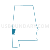
Lisman-Pushmataha, Choctaw County, Alabama
About
Outline

Summary
| Unique Area Identifier | 521377 |
| Name | Lisman-Pushmataha |
| County | Choctaw County |
| State | Alabama |
| Area (square miles) | 62.12 |
| Land Area (square miles) | 62.08 |
| Water Area (square miles) | 0.04 |
| % of Land Area | 99.94 |
| % of Water Area | 0.06 |
| Latitude of the Internal Point | 32.18104060 |
| Longtitude of the Internal Point | -88.34682880 |
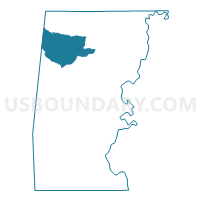
Maps

Graphs
Select a template below for downloading or customizing gragh for Lisman-Pushmataha, Choctaw County, Alabama


Neighbors
Neighoring Voting District (by Name) Neighboring Voting District on the Map
- Butler-Lavaca-Mt. Sterling Voting District, Choctaw County, AL
- Crossroads-Intersection-Halsell Voting District, Choctaw County, AL
- Riderwood-Rock Springs, Choctaw County, AL
- Snell Voting District, Clarke County, MS
- Whynot Voting District, Lauderdale County, MS
- Yantley-Cromwell, Choctaw County, AL
Top 10 Neighboring County Subdivision (by Population) Neighboring County Subdivision on the Map
- District 5, Lauderdale County, MS (16,062)
- Butler CCD, Choctaw County, AL (4,423)
- Lisman CCD, Choctaw County, AL (3,184)
- District 4, Clarke County, MS (3,050)
Top 10 Neighboring Place (by Population) Neighboring Place on the Map
Top 10 Neighboring Unified School District (by Population) Neighboring Unified School District on the Map
- Lauderdale County School District, MS (39,113)
- Choctaw County School District, AL (13,859)
- Enterprise School District, MS (3,967)
Top 10 Neighboring State Legislative District Lower Chamber (by Population) Neighboring State Legislative District Lower Chamber on the Map
- State House District 65, AL (38,681)
- State House District 68, AL (36,234)
- State House District 81, MS (22,670)
Top 10 Neighboring State Legislative District Upper Chamber (by Population) Neighboring State Legislative District Upper Chamber on the Map
- State Senate District 22, AL (137,373)
- State Senate District 24, AL (118,832)
- State Senate District 33, MS (56,120)
Top 10 Neighboring 111th Congressional District (by Population) Neighboring 111th Congressional District on the Map
- Congressional District 3, MS (756,924)
- Congressional District 4, MS (754,015)
- Congressional District 7, AL (603,352)
Top 10 Neighboring Census Tract (by Population) Neighboring Census Tract on the Map
- Census Tract 106, Lauderdale County, MS (7,630)
- Census Tract 9568, Choctaw County, AL (4,423)
- Census Tract 9501, Clarke County, MS (4,359)
- Census Tract 9567, Choctaw County, AL (3,184)